Showing posts with label weather. Show all posts

Friday, February 6, 2015

A Naturalist's Thoughts on Winter Weather

February in the Mid-Atlantic can bring a wide range of weather - anything from sunny and balmy to freezing cold and snowy. This variability contributes to a wide range of winter precipitation. A wintry mix is a combination of rain, snow, freezing rain, and sleet.

Rain is liquid precipitation. The diameter of the droplets determines whether you have fog, mist, drizzle, light rain, moderate rain, heavy rain, excessive rain, or a cloudburst. Cloudburst droplets, although small at 2.85 mm in diameter, are over 200 times larger than fog droplets. (I wrote a previous post on this topic called How Big Are Raindrops?).

Snow consists of ice particles frozen into complex, six-sided patterns. Non-branching ice crystals - or diamond dust - form in the shapes of needles, columns, or plates.

Little Brother was very little when I took this photo of him playing in the snow.
He was very proud of his snowman!

Freezing Rain occurs when the atmosphere is warm enough for rain, but ground temperatures are 32 degrees F or lower. The rain freezes instantly when it hits the ground, coating everything in a layer of ice. Freezing drizzle is similar, but the individual drops of water are smaller. Freezing fog occurs when ice crystals are suspended in fog.

 I took this picture after an ice storm last winter. The rain froze the instant it hit the tree branches.

Sleet forms when snow melts in the atmosphere and then refreezes before it hits the ground. Sleet does not stick to objects the way freezing rain does.

This article (sans photographs) was first posted at the Audubon Naturalist Society. Come visit Woodend!

Sunday, September 7, 2014

Mackerel Sky

I love clouds. There's something alluring about their ephemeral beauty. Each morning, I look to the sky to see what surprises Mother Nature has in store for me.

Today, I found a mackerel sky. This is a cloudscape that looks like rows of fish scales, or, as I like to think of it, a popcorn sky.

Altocumulus

Technically, these rows of small puffy clouds are altocumulus, mid-level cumulus that form in the lower middle portion of the sky. These clouds are sometimes confused with cirrocumulus, although the two form in very different vertical layers. If you look through the bumpy rows of clouds and the sun looks fuzzy, you've spotted the rarer and higher lying cirrocumulus.

Cirrocumulus

Over on NASA's S'COOL website (Students' Cloud Observations On-line), Lin Chambers suggests holding your hand up at arm's length when trying to differentiate between these two cloud types. If the individual clouds are the size of your thumbnail, you have altocumulus; if they are the size of your pinky fingernail, you have cirrocumulus.

Note: Since I posted this, I've learned that the term mackerel sky can be used to describe either cirrocumulus or altocumulus or both! 

[Edited 9/14/14]

Thursday, October 25, 2012

Preparing for Frankenstorm

Weather forecasters have given the east coast of the United States the ominous prediction of a "Frankenstorm" early next week -- an anticipated massive collision between the warm & wet tropical air mass known as hurricane Sandy and an arctic blast from the north.  Rain?  Snow?  Damaging winds?  All of the above?  It depends upon which model you believe, although most tend to be converging on an unpleasant combination of the three that may extend as far inland as Ohio.

Regardless of which weather model you trust, what seems obvious to me is that I'd better get prepared.  But what does that mean?  How do you prepare for an emergency?  The Federal Emergency Management Agency (FEMA) has an entire website called Ready devoted to the topic, where you can learn how to build a Basic Disaster Supplies Kit, create a Family Emergency Plan, and Graduate from Readiness U!  The National Weather Service also has an entire section of their website devoted to Weather Safety.

In my situation, I can expect a power outage.  I may get stuck at home for a few days.  So I need to check our stores of drinking water, easy to prepare food, and essentials like medicine and toilet paper.  I can't plan to do any laundry past Sunday, so I'd better get to that now.  I should also gas up the car, load up on groceries (although perhaps not too many perishables), and get cash from the bank.  Flashlights, candles, and warm blankets should all be placed within easy reach.  And maybe I should head over to the library for something to read, just in case.

In any event, stay warm, dry, and safe this Halloween.  And keep an eye out for Frankenstorm!

Tuesday, August 21, 2012

When You Give a Three-Year-Old a Camera

Yesterday, my three year old daughter asked if she could use the weather app on my iPhone. Now, granted, I think she just wanted to get in the request before her older brother Kerm did. But I was tickled that she asked, so I handed the phone back to her. Unbeknownst to me, she not only knew how to locate the camera function, she decided to use it. Now, I've blogged about Kerm and Little Brother's love of photography before, so it shouldn't come as a surprise that their little sister enjoys taking pictures too. But what I think is fascinating about young photographers is the truly unique perspective that they bring to their art. You can learn a lot about a child by looking at his or her photographs. Princess Twinkle set out to capture the view of rain from her car seat. These are some of the pictures that she took today.
Perhaps I was driving a little fast here ...

Saturday, March 24, 2012

Why Toddlers Are Fun


Morning fog.

I tell the toddler
the cloud fell down.

We need, she says,
to tape it up.


Photo credit: comedy_nose, via flickr // CC BY 2.0

Tuesday, March 23, 2010

Happy World Weather Day!


Well, it turns out that today, March 23, 2010, is full of special events -- it's Free Pastry Day at Starbucks (print out the coupon quickly & rush to order your coffee, the offer ends at 10:30 am!), Free Cone Day at Ben & Jerry's (good from noon until 8 pm, head there after you get your pastry at Starbucks!) and it's also World Meteorological Day 2010, as proclaimed by the World Meteorological Organization.

Sadly, apart from the kind folks on Twitter who alerted me to this special day, there doesn't seem to be much enthusiasm for World Weather Day -- no mentions on The Weather Channel or WeatherBug and not many hits on Google either.

That is just sad. Let's face it, no matter where you live on the globe, weather affects your daily life. Even the folks up on the International Space Station have to worry about weather when it's time to come home!

Yesterday's World Water Day received far more press, and water is just one component of weather. Weather is bigger than water! So, in honor of World Weather Day, let's start some new traditions:

* Visit a weather-themed science exhibit, like the Chicago Museum of Science and Industry's Science Storms, described by Kara Spak of the Chicago Sun-Times as "a science lab on steroids."

* Take a minute to look up at the sky. Is it partly cloudy or partly sunny? "Meteorologists like to say that the difference between 'partly cloudy' and 'partly sunny' is the forecaster's mood," according to this fun set of questions & answers from USATODAY.com.

* Watch Cloudy With a Chance of Meatballs.

* Browse the weather-themed topics on this blog. Don't miss The Science of Snow and How Big are Raindrops?

* Make your own book of weather words! How would you draw smoggy or snowy?

* Remember special weather days in your own history. Has weather played a crucial role on certain days of your life? I know it has for me! On the night before I married Itinerant Cryptographer, we had a big stormy cold snap. In the morning, there were no flowers (save some leftover funeral bouquets!) in the church where we were to be married. The florist's excuse was that the doors to the company van had frozen shut. They couldn't deliver the flowers until they'd warmed up the van -- and until half of our wedding pictures had already been taken.

However, you choose to celebrate, enjoy the weather today!


Photo credit: Bex Ross, via flickr //CC BY 2.0

Saturday, February 6, 2010

The Blizzard of 2010

This is what I woke up to this morning.


Believe it or not, there are cars under there!


I have to admit, when the weathercasters referred to our December 2009 snowfall as a blizzard, I was skeptical. But this snowstorm clearly meets the definition. Intense snowfall, heavy wind, broken tree branches, and, of course, lots and lots of snow. And, 24 hours later, it's still snowing!

Look at the amount of snow on that mailbox!
Note the broken tree branch in the background.

The Science of Snow

Two years ago, I had the pleasure of interviewing Dr. Joseph M. Moran, of the American Meteorological Society, for an article about snow that appeared in Washington Parent magazine. Given that snowy weather has taken over much of the United States, I thought you might enjoy this reprint of our conversation.

***

The Science of Snow: Ask the Expert!

Dr. Joseph M. Moran, of the American Meteorological Society, answers your questions about snow:

1. Is it true that no two snowflakes are alike?

Dr. Moran says, "‘No two snowflakes are alike' is a widely held assumption. Although all snowflakes are composed of ice crystals having six-sided ... symmetry, they may occur in billions of different forms." Even so, a researcher discovered two identical snowflakes while sampling clouds over Wisconsin in 1988.

2. Are there different kinds of snow?

"Yes," says Dr. Moran. He explains, "Snow is an agglomeration of ice crystals in the form of flakes that develop in clouds and fall to the Earth's surface. Snowflakes vary in shape and size depending on air temperature and humidity. With decreasing cloud temperature, snowflake crystals occur as needles, dendrites, plates, and columns."


A dendrite snowflake below; a plate snowflake on the right. Both of these images were taken by Wilson "Snowflake" Bentley. For more information, SnowCrystals.com has nice descriptions of different types of snowflakes.


"Snowflake size depends in part on how humid (moist) the air is. At very low temperatures, the humidity is relatively low, and snowflakes tend to be small. Snowflake size also depends on the efficiency with which they collide with one another as they fall through the atmosphere to the ground. At air temperatures near freezing, snowflakes more readily stick together after colliding, and their diameters sometimes reach 2 to 4 inches (5 to 10 centimeters). Snow pellets and snow grains are similar to snowflakes but much smaller. Snow pellets are soft conical or spherical white particles of ice with diameters of 2 to 5 millimeters. Snow grains are flat or elongated opaque white particles of ice, usually less than 1 millimeter in diameter."

3. How do meteorologists measure snow? My measurements at home never seem to match what the weathercaster says.

Meteorologists measure three things, says Dr. Moran: "The depth of snow that falls between successive observations, the meltwater equivalent of that snowfall, and the depth of snow on the ground at observation time."

Dr. Moran tells us how to measure a storm's snowfall like the experts. "Prior to an anticipated snowfall, place a simple wooden board on the ground ... New snowfall accumulates on the board, and at observation time a ruler is used to measure the snow depth to the board. Record the snowfall ... and sweep the snowboard clean so that it is ready to receive new snowfall. Repeat this process throughout the snow event, and then compare your total snowfall with that reported by the local television or broadcast meteorologist. Note that snowfall is notoriously variable from one place to another ..." depending upon things like temperature, the distance you are from the ocean, and the track of the storm.


Photo credits: Wilson Bentley, from NOAA's National Weather Service Collection.

Friday, February 5, 2010

Ten Tips for Celebrating Snow Days

With the forecast for much of the United States calling for snow sometime in the next week, I thought I'd re-post these ten tips for making the most of snow days. (This post is excerpted from my original article, which was published in Washington Parent magazine in January 2007.)


The forecast is grim: snow, snow, and more snow. What are you going to do all day? Before you go stir-crazy, try these ten tips for turning a snow day into together time:

1. Have an all-white day. Encourage everyone in the house to wear white. Prepare your family all-white meals like oatmeal with milk for breakfast and chicken breast, mashed potatoes and cauliflower for dinner.

2. Make snow-themed treats together. Bake your favorite cookies and add a dusting of powdered sugar "snow" on top. Make marshmallow snowmen using candies for eyes, raisins for buttons and pretzel sticks for arms.

3. Read about Wilson "Snowflake" Bentley. Virginia mom Karen Cole, founder of Big Learning, suggests the book Snowflake Bentley by Jacqueline Briggs Martin and the Snowflake Bentley website. In 1885, Bentley became the first person to photograph individual snowflakes; in his lifetime, he took pictures of more than 5,000 different snowflakes (including the picture at the top of this post!).

4. Have a snow-inspired movie marathon. Bring out snowy family favorites like Ice Age and March of the Penguins. To increase the educational value, break out the encyclopedias or hop on the Internet to learn about glaciation or the continent of Antarctica. Be glad that you don't live at Vostok Station in Antarctica, where the coldest recorded temperature on Earth was observed on July 21, 1983 (-128.6°F / -89.2°C).

5. Conduct scientific experiments with snow.

"Even though freshly fallen snow appears bright white and clean, it is not," says Dr. Joseph M. Moran of the American Meteorological Society. Dr. Moran is the author of a brand new textbook, Climate Studies: Introduction to Climate Science.

"One of my favorite activities goes a long way to convincing children not to eat snow. You will need a 1- or 2-gallon pail, large paper coffee filter, paper towels, and a magnifying glass … Scoop up a large pail of freshly fallen snow and bring it indoors to a warm room. Set the pail down undisturbed until all the snow melts. Then, over a sink, slowly and carefully pour the meltwater through a paper coffee filter. Set the coffee filter aside on some paper towels until it dries. Next, examine the surface of the dry coffee filter … What do you see? Where did that material come from?"

He adds, "As snowflakes fall through the atmosphere, they intercept and capture a variety of tiny particles that are suspended in the atmosphere and carried by the wind. Most of these particles originated at the Earth's surface. [You can] speculate on what these particles might be."


6. Have your kids play "cool" word games. For example, ask them the following questions: How many words can you think of that start with the word "snow"? (snowflake, snowplow, snowstorm, snowmobile …). How many words can you make from the letters in the word "snowflake"? (sow, now, lake, wake …). For a harder challenge, try making words from the letters in the word "avalanche" (ache, vale, lava, leach, lane …).

7. Try recipes made with snow. (Although, after reading Dr. Moran's comments, you might wish to make your own "snow" by mixing ice from the freezer in your blender!). Scoop up some fresh snow, and mix it with fruit juice to make a snow cone. Or make Snow Cream: Scoop snow into a large bowl, and blend in 1 cup milk or cream, 1/2 cup sugar and a few drops of vanilla. Enjoy!

8. Compete in your version of the Winter Olympic Games. See who can throw a snowball the farthest or sled down a hill the fastest. Stuck indoors? Glide over the kitchen tiles in your socks and have an ice-skating competition.

9. Go outside and examine individual snowflakes.

Dr. Moran says, "This activity requires a sheet of black construction paper or a dark cloth, a magnifying glass, a journal and a pencil. During a snowfall, go outdoors and hold the construction paper or cloth horizontally to catch some snowflakes. Take care that the heat from your breath or fingers does not melt the snowflakes. Using the magnifying glass, examine the individual snowflakes. Describe what [shapes] you see, and draw some of them in your journal. Are any of the snowflakes identical in appearance?"

He notes, "Recording data in a journal is a good introduction to scientific observation and the scientific method."


10. Share your family's favorite snowy memories. Do you remember when you saw snow for the first time? Ever caught a snowflake on your tongue? What was the deepest snowfall that you can remember? You might be surprised at what your family members share with you. Sometimes, a day spent together "doing nothing" turns into a cherished memory.


Photo credit: Wilson Bentley. This picture is part of NOAA's National Weather Service Collection and was taken in 1902.

Wednesday, January 6, 2010

Weather words


Earlier this week, Itinerant Cryptographer came home and announced, "I signed us up to run the activity at Boy Scouts next week. Our topic is weather."

Now, if you've read this blog before, you know how much I like meteorology! But I'm at a loss for an appropriate weather-related activity to try with a group of third grade boys. So, I consulted with my favorite four-year-old.

"What should Mommy and Daddy do next week to teach about the weather?" In the back of my head floated images of cotton ball clouds, weather station data, and field guides full of bizarre weather phenomena (like lenticular clouds).

Little Brother's response, however, was simple and delivered with great enthusiasm. It didn't matter what the big boys did next week. He wanted to try this today.

"Let's make a weather book!"

So we did. I took one sheet of black construction paper and five sheets of drawing paper, stacked them neatly, and folded them in half so that the black paper formed a cover. Then I punched three holes down the fold and tied some ribbon for the binding. I gave Little Brother a list of 17 weather terms -- like wet, partly cloudy, foggy (can you think of more?) -- to illustrate and let him choose the ones he wanted to copy into his book.

Little Brother did a great job! Here are two of my favorite pages:


Photo credits: Mama Joules. Images courtesy of Little Brother.

Saturday, December 19, 2009

Snow!

The view from my back door


Where I live along the Eastern seaboard in the US, we are in the middle of a record-breaking snowfall. For you folks out west or in other snowy climes, this storm wouldn't seem like much. But here, this quantity of snow is shocking!


Kerm and Little Brother went sledding today -- the first time ever for Little Brother. They had a wonderful time. :)

Tuesday, December 8, 2009

Make-A-Flake

Last year, I wrote a post about the joy of paper snowflakes, and how it was fun to make them both on- and off-line. One of the websites my kids and I enjoyed was Barkley Interactive's Make-A-Flake.

Little Brother made his own snowflakes this year!

Make-A-Flake is fun because you get to see how to properly fold (virtual) paper to make a six-sided snowflake. You can cut (and re-cut) with your virtual scissors to get the desired effect. A trip through Make-A-Flake's snowflake gallery reveals a wide range of artistry. Some snowflakes are very simple, others are truly amazing. Can you tell which cuts were needed to make them?

I can't visualize my snowflakes before they are unfolded to reveal their shape. Can you predict what yours will look like? I think it's an interesting test of spatial awareness. As person with only one working eye, I have some limitations in that area.

I enjoyed making some snowflakes, too. I think this one looks like six aliens around a campfire. What do you think?

Saturday, December 5, 2009

The view from my front yard ...


delicate snowflakes
dancing down the darkened path --
winter's arrival


Photo credit: Mama Joules

Thursday, October 15, 2009

What is global warming?

Climate change is impossible to avoid. Scientists know that the Earth has been both colder (think Ice Ages) and warmer (the days of Titanoboa) at different times in the past. When people talk about the problem with climate change, though, they are talking about the recent, rapid increase in temperature across the planet. The majority of scientists think that the rate of change is unnaturally fast because of things people are doing, like burning fossil fuels (such as gasoline and coal).

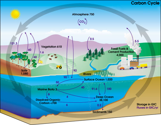
Why does burning gasoline make a difference to the planet? When talking about climate change, it helps to remember that the Earth is a closed system. We only have so much carbon on our planet. Some of it is in solid form -- carbon-based life forms like you and me and the trees outside -- and some of it is in the atmosphere in gases like carbon dioxide (CO2) or methane (CH4).

When we burn fossil fuels, carbon that was in a solid form is released and enters the atmosphere. Atmospheric carbon can then be "breathed in" by trees, grasses, and other plants to enter a solid form again. This is a rather simplified version of the carbon cycle. (In the real-life model, there's a bunch of carbon "missing" -- unaccounted for in the cycle -- and no one knows exactly where it is going [although forests seem a likely place]. But that's a topic for another blog post!)

Image credit: NASA, revised version obtained through Wikipedia Commons

The problem with the carbon cycle is that we are changing the ratio of solid carbon to gaseous carbon. When we use drive a car, cut down trees, or burn coal to heat our house, we are moving carbon to the atmosphere. Carbon isn't leaving the atmosphere as fast as it's entering it. And that's a problem.

Carbon dioxide, along with other gases in the atmosphere, acts like a shield. The sun's rays deliver heat to the Earth's surface, but the heat gets trapped in the atmosphere. Just like in a greenhouse, this reflected heat bounces back down to the earth's surface. This warms the Earth, which is a good thing because it keeps us from freezing. But adding too much carbon dioxide to the mix makes the Earth's atmosphere trap too much heat, which causes temperatures to rise. This is known as the greenhouse effect.

Image credit: NASA (taken from a 2002 online press release)

Scientists that study the atmosphere can show that the levels of carbon dioxide in the atmosphere are steadily and rapidly increasing. No one knows for sure how the Earth will adapt to these changes.

Image credit: Dr. Pieter Tans, NOAA/ESRL (www.esrl.noaa.gov/gmd/ccgg/trends)

Think of the earth as a big mixing bowl. The sun's rays are beating down on the Equator, heating up the middle of the planet, while the poles are cold and snow-capped. These differences in temperature drive our weather.

Now, let's say that global warming has increased temperatures around the world. This may not seem like much of a problem at first, especially if you hate winter. But here are three specific concerns:

1) The Earth's weather is going to change. The polar ice caps are melting. The mechanism that drives our weather -- these differences in temperature across the globe -- has been altered. The ratio of the earth's liquid water to ice has changed. These changes are affecting the world's weather. And we have little control over the changes.


South Cascade Glacier, Washington State, United States.


Photo on top taken in 1928, photo on bottom from 2006. Note that the lower part of the glacier has melted by 2006.


Photo credits: 1928 - USDA/USGS; 2006 - USGS, cropped by Mama Joules)


Weather is not easy to predict as it is. Adding more confusion isn't going to help us develop good climate models. Although we have ideas, we don't know exactly how the weather is going to change from increased temperatures. As anyone who's watched a weather forecast knows, climate models can only predict so much.

Sometimes, a model completely fails to guess what's going to happen. Climate models are at risk of failure because so many factors (even the amount of volcanic ash in the sky) drive climate change. We know that weather can cause big problems -- things like typhoons, tornadoes, flooding, and drought. If we can't plan for the future, we will be unprepared for disaster when it strikes.

2) Some plants and animals may face extinction. The rate of temperature change might be too rapid for some species on Earth to adapt. Animals that currently live in the coldest climates on Earth -- like polar bears and penguins -- have no where else to go.

Photo credit: Dave Olsen, U.S. Fish and Wildlife Service

3) The composition of ocean water is changing. Melting polar ice caps create another problem -- they decrease the salinity of the Earth's oceans. The increase in planetary carbon dioxide is also changing the ocean's acidity. The plants and animals that live in the ocean are at risk from these changes. These changes may also affect the way that the ocean functions, like how it deals with pollution or how nutrients cycle through the marine ecosystem.

What can we do? These problems facing our planet can seem overwhelming. But here are some concrete things that you can do to make a difference:

Learn about the greenhouse effect and climate change. Over 7,000 blogs have chosen today, Blog Action Day 2009 to focus on climate change. Check them out!

Reduce your carbon footprint. Your carbon footprint is the amount of greenhouse gases (like CO2) that is being released into the atmosphere because of your behavior. If you carpool, turn off the lights, recycle, and shop locally, you will be reducing the amount of carbon entering the atmosphere.

Let your voice be heard! Join organizations that are working to understand climate change. As soon as you are old enough, vote! Support candidates that understand the environmental problems facing our planet.

Study science, math, and engineering. Scientists are already finding ways to sequester carbon (moving carbon from the atmosphere back into a solid form). Someone like you can invent a new and wonderful way to help address our planet's carbon problem!


(My thanks to Kerm and Itinerant Cryptographer for providing helpful comments on early drafts of this post.)

Monday, July 14, 2008

Tail Clouds

Wall Cloud with a Tail Cloud
Photo credit: NOAA Photo Library, NOAA Central Library; OAR/ERL/National Severe Storms Laboratory

I was watching the news the other night and saw a picture of a tail cloud. As an amateur sky-watcher, I was very interested, because I had never seen anything like it before. To me, a tail cloud looks kind of like a horizontal tornado, forming just above the ground. Storm chaser Mike Hollingshead of Extreme Instability does a better job of explaining it -- with great photographs -- on his Storm Glossary/Info page. I now know what a "Beaver Tail" and the "Bear's Cage" are, too!

Thursday, June 5, 2008

How big are raindrops?

Photo credit: Leon Brooks, BurningWell.org

While I was taking out the trash the other night, I commented to my young son that it was misting outside.

He gave me a funny look and said, “It’s raining.”

I said, “No, it’s misting. It’s not coming down hard enough to be rain.” I started to tell him about the different ways that people might describe rain, like drizzle or light showers, but I stopped short.

How do we define rain? What are the actual meteorological classifications of liquid precipitation? I thought that this would be a simple question, but there's been some debate on the subject.

According to the National Oceanic and Atmospheric Association, drizzle consists of fine water droplets with diameters of less than 0.5 mm; rain is usually larger than 0.5 mm. Fog droplets are similar to drizzle, but they don’t hit the ground.

I found an older set of definitions from the U.S. Department of Agriculture, though the U.S. Geological Survey at The Water Cycle: Precipitation. The 1959 USDA table referenced on this site has definitions for precipitation that include fog, mist, drizzle, light rain, moderate rain, heavy rain, and cloudburst. Part of this table included the median diameters of different precipitation droplets, including 0.96 mm for drizzle and 1.24 mm on up for rain (note that these don't exactly match the NOAA definitions).

I couldn’t wrap my mind around the numbers, so I took the data about droplet sizes and made my own graph. I discovered a couple of interesting things when I sat down with the numbers.

Data taken from a USGS adaptation (The Water Cycle: Precipitation) of Lull, H.W., 1959, Soil Compaction on Forest and Range Lands, U.S. Dept. of Agriculture, Forestry Service, Misc. Publication No.768

First, none of the droplets are very big. Even the largest water droplet -- occurring during a cloudburst -- is extremely small, typically measuring less than 2/10 of an inch in diameter. (Now, I don’t know about you, but I’ve had raindrops fall in my eye and it’s hard for me to believe that they are usually so tiny.)

Second, comparing droplet sizes reveals enormous differences between the categories. Cloudburst droplets (at 2.85 mm in diameter) are over 200 times larger than fog droplets (0.01 mm in diameter).

How do scientists know these things? Here’s one way: In 1971, researcher Motoi Kumai went out into the fog armed with gelatin-coated glass slides and studied the results under an optical microscope. He measured the radii of about 20,000 fog droplets for his paper, published in the Journal of Atmospheric Sciences in 1973. (You can read Arctic Fog Droplet Size Distribution and Its Effect on Light Attenuation in the online journals at the American Meteorological Society. Interesting side note: Kumai found that long-lasting fogs have larger water droplets than short duration fogs.

So, how big are raindrops, anyway? See for yourself! The next time you see a storm brewing, take a piece of colored construction paper outside and lay it securely on the ground. Let the first few raindrops fall and then grab your paper and quickly run inside before you both get drenched. The water droplets should have made marks on your paper; you can take your own measurements. Do you think that your results will be the same or different than those found by the meteorologists? Why?

Wednesday, June 4, 2008

I can't control the weather ...

even though I really want to! I was in the middle of my planned Wednesday post about the size of raindrops (irony of ironies!) when we were hit with thunderstorms. I've lost power twice, my cable is out, and my neighbor has a big gap in their formerly pristine siding. So ... I'm going to properly shut down my computer for the night and I'll finish my post tomorrow.

(That said ... my son just told me that lightning occurs in different colors based upon how hot it is. I've never heard that, so I'm going to add it to my list of things to research!)

Stay dry, stay warm! I hope to see you tomorrow. :-)

Wednesday, May 28, 2008

Phoenix Mars Lander

Martian surface as seen by the Phoenix Mars Lander
(Photo credit: NASA)
The NASA Phoenix Mars Lander touched down on the surface of Mars on May 25, 2008. This nifty little robot, powered by a two-wing solar array, is equipped with a meteorological station, a robotic arm to collect soil samples, and a machine to analyze the samples. The robot has landed in the northern arctic plain, which is known to contain water (in the form of ice) below the ground surface. Could Mars have once supported life?

No samples have been analyzed yet, but the Weather Report for Mars was clear, sunny, and very, very cold, with a high of just -22 degrees F (-30 degrees C)!

The Phoenix Mars Lander should be working on Mars for the next three months. You can read about the goals of the exploration at Mission Overview and Mission Objectives.

Wednesday, April 16, 2008

Bubbles on the wind

Today, when I was blowing bubbles at the park with my youngest, I started thinking about the wind. My first stream of bubbles floated away to my right. Next, the bubbles drifted to my left. Finally, I had bubbles right where I wanted them, in front of my youngest. There seemed to be no rhyme or reason to the direction of the wind. I thought about how a meteorologist might describe the breeze: light and variable.

Blowing bubbles is a wonderful way to introduce the concept of wind direction. Draw a simple compass on a piece of paper using arrows to show north, south, east and west. Place this at your feet. Make sure that both you and the compass are pointing north and blow some bubbles. You or your child can keep a running tally of which direction the bubbles are drifting. If they always float toward the north, for example, you know that the wind is coming from the south.

(My thanks to my oldest for patiently blowing bubbles for me to photograph. Snips of my half of our dialogue: "Wait, wait, they're not blowing the right way. Stand over here." "No, let's try over there, that background is all wrong." "Oh, no! Can you do that again? I missed the shot.")

Monday, April 14, 2008

Drought for thought

Photo credit: Jon Sullivan

When I was in graduate school, we spent some time discussing natural disasters and their impacts on humanity. I was surprised to learn that drought was considered to be a significant natural disaster. In the United States, yearly drought-related costs are higher (on average) than flood and hurricane-incurred costs combined. (source: Drought for Kids: Comparison of Droughts, Hurricanes and Floods by the National Drought Mitigation Center of the University of Nebraska-Lincoln)

What is drought? Simply put, a drought occurs when there is a substantial lack of rainfall in a given area, enough to negatively impact people, plants, and animals.

The definition of drought, however, is unique to a given location. What would be considered a drought in the wetlands of southern Florida, for example, would be considered an abundance of rainfall in the United States’ desert southwest.

There are a couple of factors that make coping with drought challenging. For one, by the time that you realize you are in drought, it’s already begun. Pinpointing when a drought first starts is nearly impossible, although groups like the United States Geological Survey do an admirable job of searching for signs of trouble. (Among other things, the USGS monitors the flow of water in streams and rivers. Low flow signals a possible drought-related problem.)

Once you realize that you are in a drought, no one can say how long it will last. Rainfall models can only tell you so much. For city planners and others who regulate water flow, it can be difficult to decide when and how to moderate water intake. Imposing water restrictions, ironically, can make a drought situation worse if panic ensues and people begin to hoard water. UNL’s National Drought Mitigation Center describes the challenge of managing drought as "The Hydro-Illogical Cycle".

In the United States, the U.S. Drought Monitor keeps track of drought conditions. One place to check on world-wide drought situations is NASA’s Earth Observatory Natural Hazards: Crops & Drought.